ARGUS-1: our rover for the NASA Space Apps Challenge 2026
With five friends from Hackerspace Valencia I built, in one weekend, a tracked rover that prepares an astronaut's route on Mars at night: it moves rocks aside, goes around obstacles and never touches the science rocks.
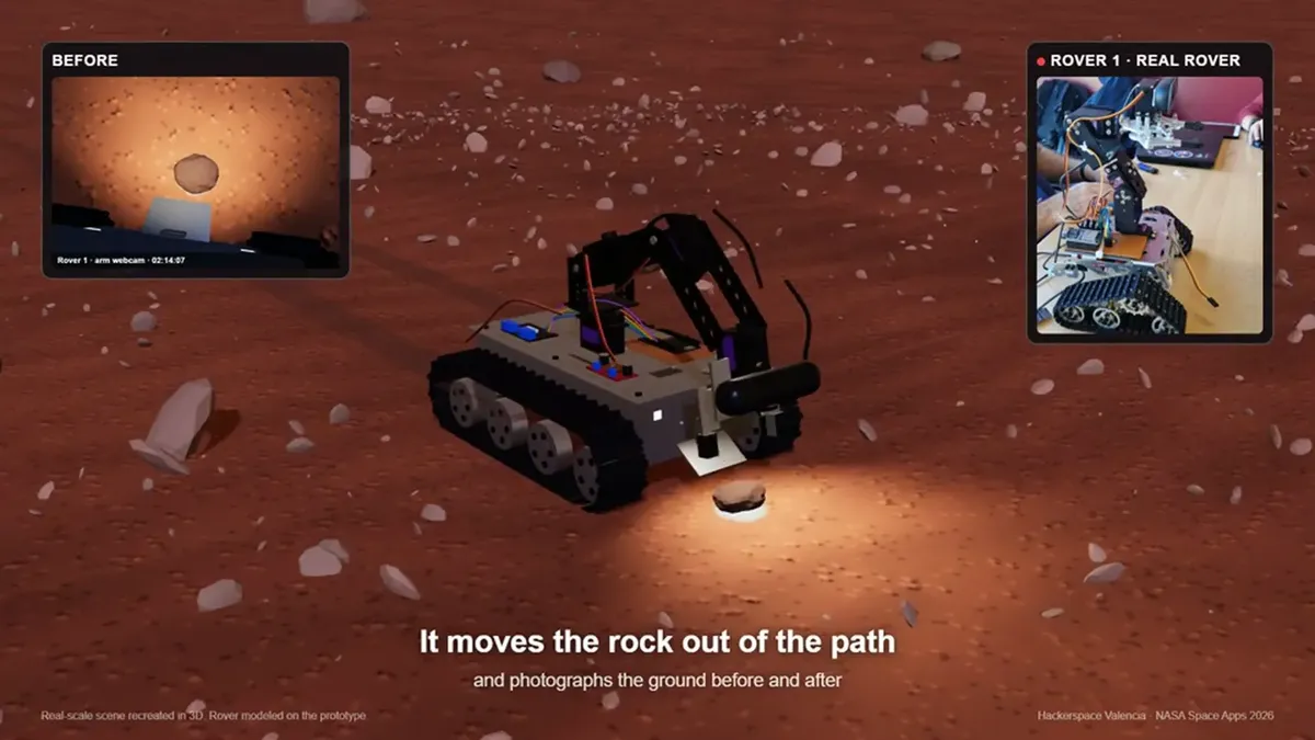
In November I took part in the NASA Space Apps Challenge 2026, NASA’s international hackathon, with five people from Hackerspace Valencia. We chose the challenge “Interplanetary Survival Guide: Martian Map” and in one weekend built ARGUS-1: a real rover with a robotic arm that drives, at night, the route an astronaut will walk on Mars the next day.
We didn’t win a prize, but I came back with a working rover, a lot learned, new friends and very good memories.
The problem
The best orbital camera at Mars, HiRISE, sees about 25 cm per pixel: a ball-sized rock is a single pixel. For an astronaut on foot, in a suit and carrying a load, that pixel can be a fall. And with the signal taking 3 to 22 minutes to arrive from Earth, nobody can drive a rover live to check the path.
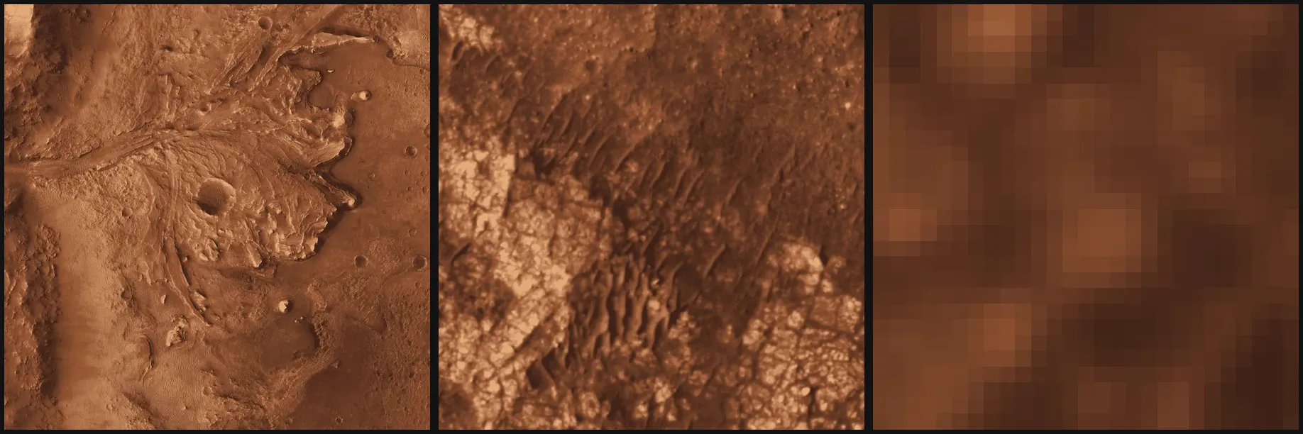
From Jezero crater to Airfield Tau to our 10×6 m plot. At that scale, the best orbital image is a handful of pixels.
We set the story at Airfield Tau in Jezero crater, where Ingenuity landed on flight 62 and Perseverance stopped about 10 m away. Helicopter first, rover second, the same order as our idea.
The idea: a night shift
While the crew sleeps, small and cheap rovers drive the next day’s route and decide what to do with each rock:
| Rock | What the rover does |
|---|---|
| Small, on the path | Picks it up with the arm, puts it aside and photographs it before and after. |
| Big | Marks it and the route goes around it. |
| Science | Photographs it and never touches it, so nothing a geologist wants to study gets spoiled. |
| Landmark | Uses it to find its way. |
In the morning, the astronaut checks a map on a tablet with every stretch already checked on the ground.
The rover
It is a tracked rover with a CNC-machined chassis and an aluminium robotic arm, plus a few 3D-printed parts: the gripper pads and a PETG sample box.
- Raspberry Pi 5: vision, decisions and the rover’s API.
- ESP32: motors and servos. It takes commands over USB or Bluetooth LE and stops everything if the Pi stops sending its heartbeat.
- Webcam on the arm: the arm is also its neck, so the rover looks around by moving it.
- Xbox controller: to drive it by hand. The two bumpers switch it to autonomous mode.
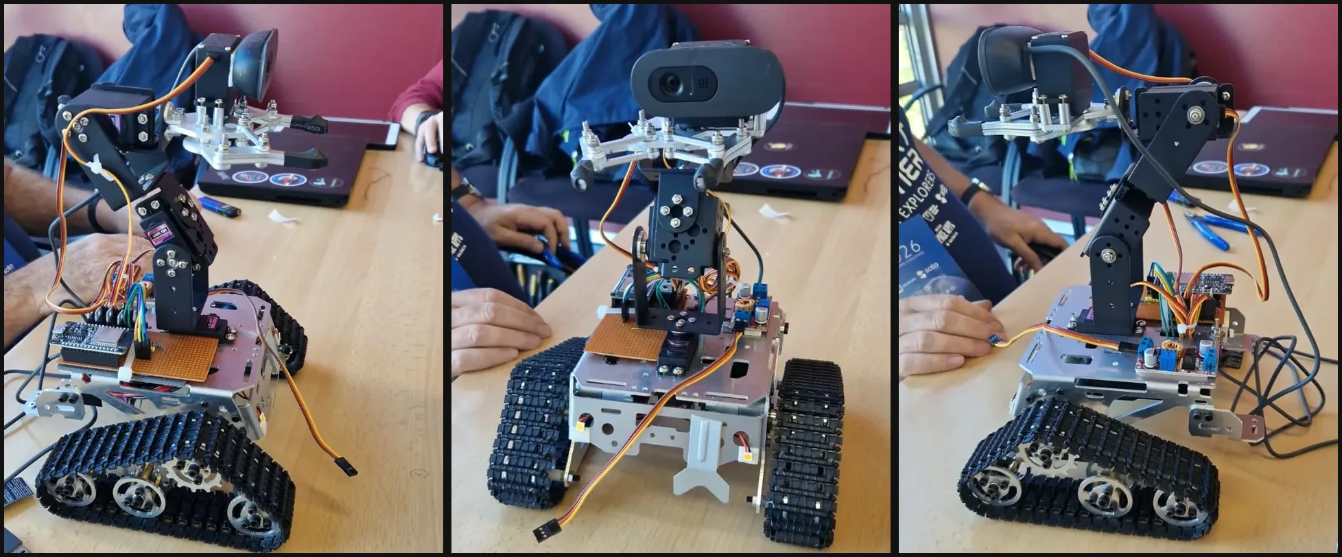
The rover on the hackathon table.
The demo runs on a 100×60 cm table that stands for a real 10×6 m plot at 1:10 scale. The rocks are props: the black ones are landmarks, the gold ones are science targets and the orange block is the one the arm is allowed to move.
A rock detector of our own
No off-the-shelf model knows what a “science rock” is, so we trained our own:
- Record: thousands of frames from the rover’s own webcam, with a controller button to start and stop.
- Label: a script auto-labels them by colour and shape, and the doubtful ones get reviewed by hand.
- Train: a small YOLO model with three classes: movable, science and landmark.
- Ship: quantized to INT8 with ONNX Runtime, it runs on the Raspberry Pi itself at about 30 ms per frame, with no internet connection.
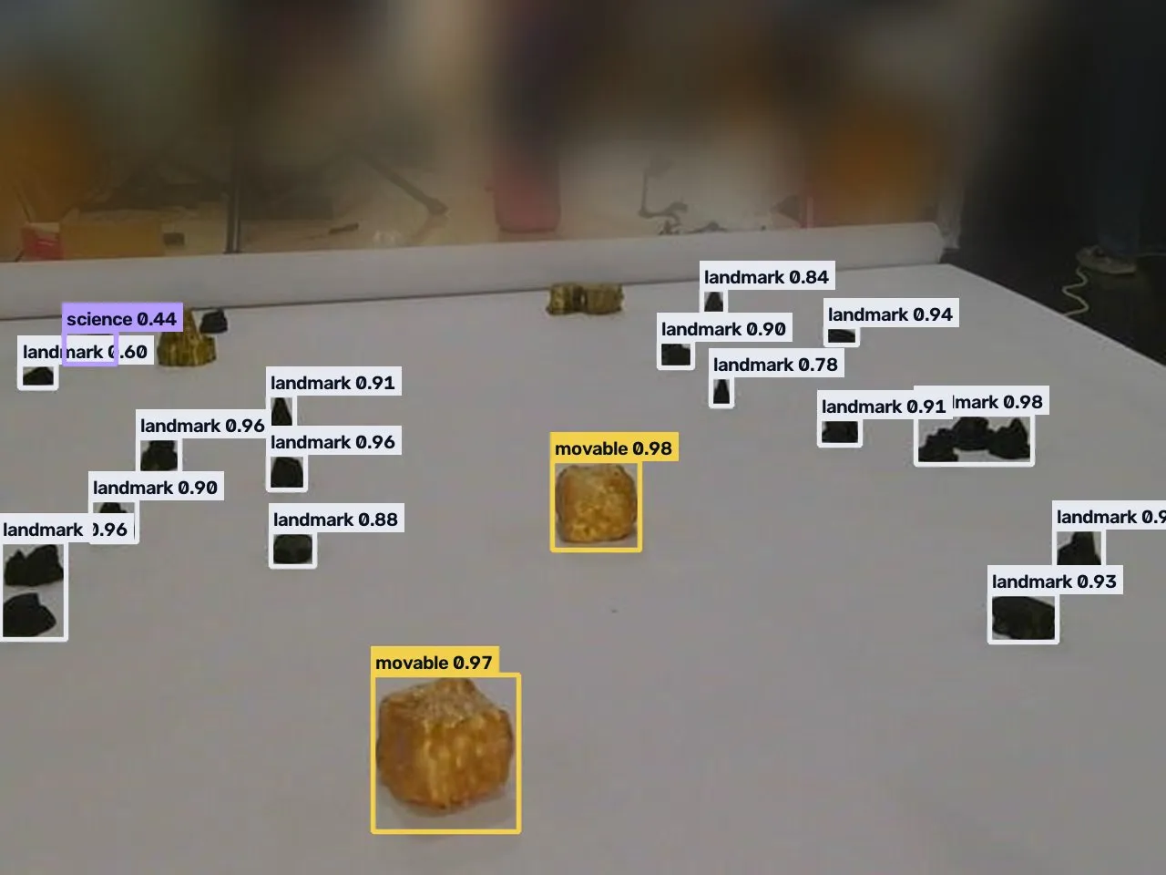
What the rover sees: movable blocks in yellow, the science rock in purple and landmarks in white.
When the lighting at the venue changed, the gold rocks started to look like the block. We recorded again, reviewed the labels and retrained until the model stopped confusing them in our tests. It mattered: a misclassified science rock is a rock the arm would grab.
The AI doesn’t move the hardware
The system has a language model to understand voice commands and narrate the mission, but it only chooses which task to run. Driving, approaching and grabbing are done by a deterministic program:
- It searches for the rock by moving only the arm, because the arm’s base angle is exact and the tracks are not.
- It turns to face the rock without losing sight of it and approaches in short steps, checking each one with the camera.
- If it loses the rock, it looks where it last saw it.
- It finishes its route even if the link to mission control drops. On Mars, the link drops.
The morning brief
Everything the rovers see ends up on a single map over real NASA imagery: the route, every rock and its state, and the before and after photos. That is what the astronaut checks over breakfast.
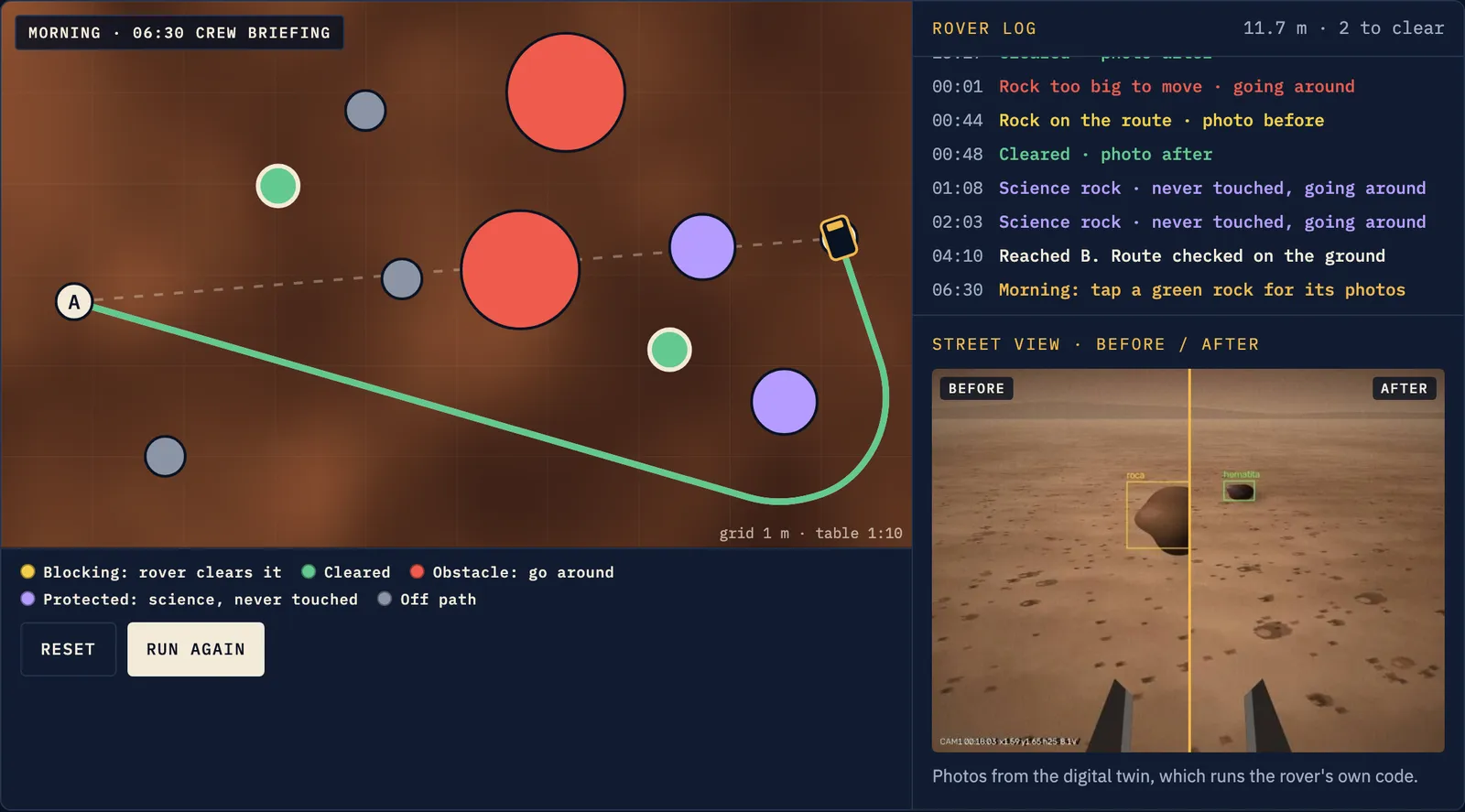
The night-shift demo on argus1.earth: place rocks, run the shift and check the route in the morning.
What I take home
We didn’t win a prize, but I take home what I learned, the friends I made along the way and a very good experience. Thank you to the organisers of the NASA Space Apps Challenge in Valencia for making it possible, and to my team: Danielyss, José, Lua, Enrique and Eugeni.
The whole project is open:
- Website with interactive demos and a 3D twin: argus1.earth
- Pitch deck: slides.argus1.earth
- Source code: gitlab.com/hackerspacevlc1/space-apps-2026
- The project on the hackerspace site: hackvlc.es
An independent team project, not affiliated with or endorsed by NASA. Orbital imagery: NASA/JPL-Caltech/University of Arizona (MRO HiRISE), via Mars Trek.
Drafted with AI, edited by hand. I publish it when it sounds like me.